This is an interactive Google map (or select other type of map from the drop-down menu) of five hikes with the gang. I suggest turning them all off at first by clicking on the names.
Then turn on the track for the hike description being read.
"Waimano (short)" of 2013 (yellow track), ironically the longest one tracked here (I have yet to take a GPS to the summit),
goes only to where some hikers stopped for lunch and turned back, short of the manuka lunch spot, I believe.
The green 2010 track shows a hike that went up to the end of the ridge behind the Boy Scout shelter;
on the way back we took the turn down to the lower trail.
In June 2012 a few of us started out on the lower trail, but stayed in the valley to about the makai (west) end of the "Boy Scout" ridge,
where we climbed to the regular Waimano trail. The track ends at the second stream crossing up-valley from the Boy Scout shelter.
Some of us once turned back there because it was raining and the water was high; maybe this was that day.
The purple track from November 2012 follows a path of Joe Busson's, climbing from the Waimano ridge trail to the water tank
on the road beyond the Waimano buildings. It continues on a loop of part of the Halapepenui trail.
Red 2014-04-09 track: There is a level place above a short clamber early on along the upper ridge trail.
I noticed a trail heading down westward from there and explored it a bit, thinking it might be another way down to the
lower trail; switching to a topo map such as USGS + relief seems to confirm my surmise. Only then did I turn on my GPS to mark the spot,
having left it off because I had enough tracks of this area. But I left it on the rest of the way, which for me was where the trail turns sharply up
to the right not very far past the stream crossing. I stopped there for lunch where I had eaten on the 2013 hike.
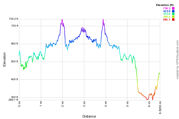
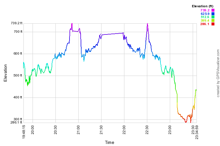
Finished this hike once again by turning down onto the lower trail.(There are distance and time profiles for this hike below.)
I haven't been good about giving way-points proper names. "POI027" is where we turn down from Mānana for ʻIliahi Ridge and "POI008" is the stream crossing.
"POI022" is where one turns off Waiao for Halapepe Nui.
Subtract 10 hours from the times for local Hawaiian time.