One Wild Hike

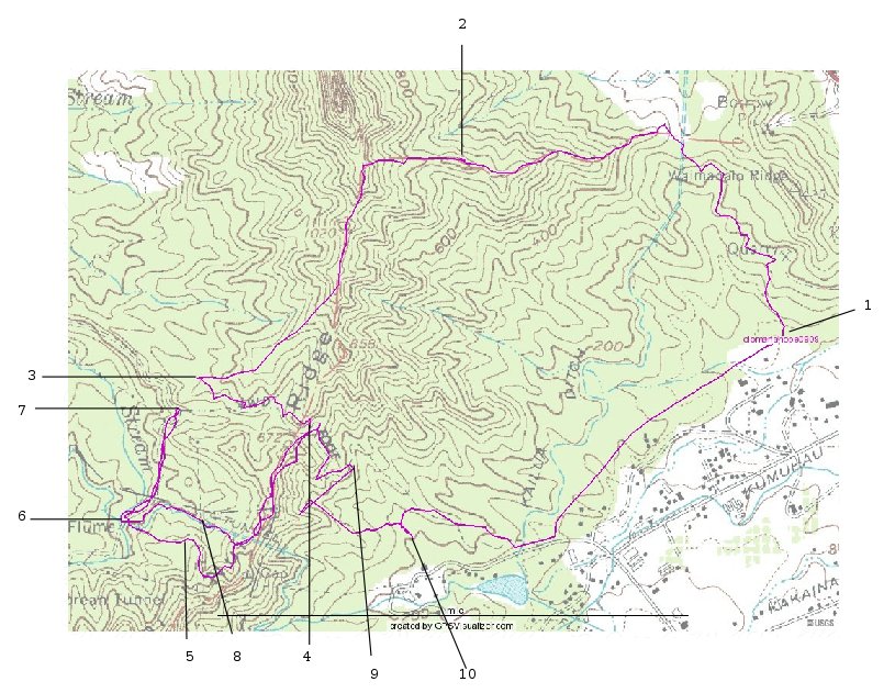
The hike started out normally, the usual big crowd of old and new hiking friends, meeting at "1" on the topo map.

Then Joe gave us the lowdown on a new option for the end of the hike: go through a water tunnel that won't exist much longer. I had already decided I didn't want to wade, so I didn't pay a lot of attention to the details, but I knew roughly what he was talking about when he said 'flume' due to one of my many wrong turns hiking when we did this 2008-02-13 (I may have led a bunch astray that day, but others far ahead had also missed the proper turns).

I carried two ropes for possible use going around the rock at the top of the first hill (2 on topo). I have advocated going around the rock on the right side, rather than the traditional left, feeling it was somewhat shorter and didn't require any rope. This time, many followed me around that side, but the last steep climb seemed to need a rope, so I hung the shorter one down. Then a bunch of people who didn't see anyone going around the right took the familiar left hand approach, and they too needed a rope, so I fastened one end of the longer one to a tree on the finish side and had the other end passed back to someone to tie where needed. Once everyone had passed the rock, I recovered both ropes, and found that traversing the left hand side of the rock wasn't nearly as bad as I recalled (I hadn't tried that side for three years or so).

Things went on fairly uneventfully until Hideo and I reached the spot (3) with a backwards fork that Joe had marked as "Bailout Trail." We planned to take that, but I thought it would be a good spot to stop for lunch, and I could sort of clue people in about the options. I told the ones (most?) that were going to do the tunnel route that they should continue the way they were going until they reached a road, turn left on it and follow it down when it curved to the right, until they got to the bottom of the valley where there would be some kind of steel and concrete structure; I didn't clearly remember the red pipe at that moment.

Lunch done, Hideo and I took the "bail-out" route, almost immediately reaching the point where that trail met the Maunawili Demonstration trail (4). For some reason (I was confused again!) that surprised me, so I decided to hike out the Maunawili trail and drop down (5) to the pipe (6). Hideo came with. And as it turned out, we got there before any of those I had been directing from our lunch spot at the fork in the trail!

We pushed on, met some of the people heading in for the tunnel, until I reached Joe, standing at a fork with an option for the "bail-out" trail. I had intended to follow it out (Hideo had turned around with some of the hikers heading in), but after listening to people we had passed asking for instructions from Joe, I decided I had better go back down and see if I could help out. Probably just as well; a number (six or seven) of people had crossed the stream following the pipes uphill in a totally wrong direction (like the black line toward the "6" on topo). Once they were all back on the road, we made tracks along the ditch to the tunnel (8), but instead of going through it, I climbed the hill above it back to the Maunawili trail and back to the road out (starting at 4).

I was surprised to meet Joe again at about point 9, where he directed me to follow a side trail he called the "ditch trail." (My Magellan GPS obviously lost satellite contact along here.) When I got to a ribboned trail heading down, I took it, and passed up a couple of chances to turn left back to the cars, until I saw that I was coming out (10) at the big lot where we park to do Maunawili trail hikes, and went back up and turned on the first one I came to. I came out on the road below the entrance to the ditch trail, so followed the roads back to point 1, both 0.0 and 6.1 miles from where I started.